Sunday, 19 January 2014
Kevin Lynch: The Image of the City (1960)
The Image of the City is one of the most representative works of Kevin Lynch. “It is a book about the look of cities, and whether this look is of any importance, and whether it can be changed”. Lynch revealed a new approach of how to analyse and improve the visual forms of cities, which is still widely used in urban design studies nowadays.
The book has a clear structure with a straightforward topic. In the first section, new concepts of legibility and imageability are presented to lay the theoretical foundation of the entire book. Followed by that, Lynch introduced three cities as examples to reveal his outcomes of field reconnaissance, and then made comparisons between each other. In the third section, five elements and their interrelationships are summarized from previous researches which act as the core content of the book. Afterward, specific design processes and approaches are demonstrated in order to achieve strong and continuous imageability in cities and even larger metropolitan scales. Lynch pointed out the form of the metropolis is a sophisticated system rather than a static hierarchy. At last, research methodologies are presented in appendices for the readers’ reference.
In Lynch’s view, image can be explained as “a picture especially in the mind”, a sentimental combination between objective city image and subjective human thoughts. The productions of environment images are influenced by a two-way process between the observer and the observed. The observer, with great adaptability and in the light of his own purposes, selects, organizes, and endows with meaning what he/she sees. Therefore, the specific image can be totally different from the different perspective of observers, just like there are a thousand Hamlets in one thousand people’s eyes.
A well designed environment image will improve the sense of security for people and set up a harmonious relationship between the outer world and themselves. Environmental images may be analyzed into three components: identity, structure and meaning. First of all, identity defines the identification of an object which implies its distinction from other things. Second, the image must include the spatial or pattern relationship of the object to the observer and to other objects. Finally, this object must have some meaning for the observer, whether practical or emotional. A highly imageable city should be well formed, distinct and remarkable, even daily lives of people can also be redefined and given brand new meanings.
In the next chapter, three totally different cities are presented to explain Lynch’s theory. As for methodology, on the one hand, he explored the city with field research and demonstrated the image condition through unique maps. Along with this, questionnaires and interviews were given to citizens to evoke their own images of the physical environment. In my opinion, Boston represents the so called European style cities with a long history and rich culture, while this thematic vividness is typically associated with formlessness or confusing arrangements. As for Jersey City, the comment is completely negative. There is nothing but a complete confusion of an uncoordinated street system, with formlessness of space and heterogeneity of structure that mark the blighted areas of America. Los Angeles, on the contrary, is the example of newly developed cities in America, its straightforward roads and undifferentiated grid patterns are also the general models of almost all the newly-built cities in developing countries. However, except by minute attention to the distant background, it would be hard to distinguish L.A. from the centres of many other cities.
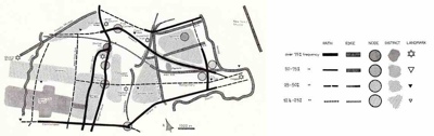
After his field reconnaissance, Lynch summarized the physical form of city image into five elements: paths, edges, districts, nodes and landmarks.
Paths are the dominant elements in urban space. Typical spatial characters, unique façade decorations are both helpful to strengthen the image of particular path. First and foremost, a path must be identifiable, and then followed by its continuity. Moreover, paths with clear and well-known origins and destinations have stronger identities and help tie the city together. After the directional qualities are determined, the next step is to consider the scale characters of paths. A series of nodes and landmarks are the most common way to achieve it. In general, it is impossible to create a clear city image while its paths remain confused and disordered.
Edges are boundaries which separate two districts with visually predominant and continuous form. While continuity and visibility are crucial, strong edges are not necessarily impenetrable. Many edges should be defined as unity seams rather than isolating barriers, some of them are often paths like highways and rivers which become effective orientation elements as well.
Districts are relatively large city areas with common characters which observers can mentally go inside of. The physical characteristics that determine districts are thematic continuities which may consist of an endless variety of components: texture, space, form, detail, symbol and so on. These components are imaged and recognized in a characteristic cluster in order to establish a striking contrast. Besides, a certain reinforcement of clues is needed to produce a strong image of an entire district.
Nodes are strategic foci which observers can enter, which are not only small points but also squares, linear shapes and central districts etc. Basically, there are two types of nodes: junctions of path and concentrations of characteristics. A successful node should have unique features inside, and intensify some surrounding characters as well.
Landmarks are reference points external to observers, which can be defined as simple physical elements may vary widely in scale. Singularity is the key physical characteristic of landmarks, creating spatial predominance through contrast with surrounding elements, making them unique or memorable in urban context.
After all, these elements can not exist individually, they must act together as a whole to reveal an integrated city image. It is a total orchestration of these elements which combine together as a vivid and dense image. Districts can be constructed by nodes, defined by edges, penetrated by paths and dominated by landmarks. Such combinations may reinforce one another, resonate so that they enhance each other’s power, or they may conflict and destroy themselves.
The image of cities is a dynamic and ever-changing object, it may differ not only by scale, but also by viewpoint, time and season. Moreover, observers are able to select, remove, and increase elements to organize their own city image either. Therefore, what we are pursuing is an open and ever-developing image rather than a fixed one-way outcome to describe city.
Nowadays, cities are growing larger and larger, but their form will not be a simple gigantic and stratified order. Instead, it will be a complicated pattern, continuous, complex and mobile. It must be plastic to the perceptual habits of thousands of citizens, open-ended to change of function and meaning, receptive to the formation of new imagery. What is more, we need an environment which is not simply well organized, but poetic and symbolic as well.
Above all, cities have specific spatial structure just like architecture, but in an enormous scale, which will take us a much longer time to perceive and understand. Urban design can be regarded as an art of time, but it differs from other time-based arts such as music. The regulations of urban design are overturned, interrupted and even abandoned with different circumstances and different people. This book is about the image of a city, about its importance, its variety and how citizens react to it. Lynch summarized the basic elements of the image and revealed an approach of how to improve it. Besides, this is also a milestone work which provides us a new perspective to read the cities we live in. From here on, subjective views of citizens and their opinions are introduced into urban design. In many ways, this book is a masterpiece highly recommendable to all architecture and urban design students.
Monday, 17 December 2012
Kevin Lynch: The Image of the City (1960)
Wednesday, 28 March 2012
Kevin Lynch: The Image of the City (1960)
MA A+U student Pablo Agustin Estefanell has published his review of Kevin Lynch's seminal urban design book The Image of the City on his new blog
Pablo's blog also contains a record of his wider design research produced during his time with us in Manchester and links to his portfolio.
Monday, 17 January 2011
Kevin Lynch: The Image of the City (1960)
Reviewed by Natalie MacBride
Introduction
Born in Chicago in 1918, Kevin Lynch’s studious desire for city design commenced in 1935 at Yale University where he studied Architecture. In addition to his studies, he worked at Taliesin (1937-1939) which was the winter home and studio of Frank Lloyd Wright and was the place where some of Wright’s much-published designs were conceived including Falling Water in Pennsylvania and the Guggenheim Museum in New York.
Subsequently, Lynch attended Rensselaer Polytechnic Institute (1939-1940) and following this, he attained a degree (1947) in City Planning at the Massachusetts Institute of Technology (MIT), which is a world leading institute for research.
After completion of his studies, his passion and enthusiasm for urban design was richly rewarded when he was appointed Instructor of Urban Planning at MIT (1948), Assistant Professor (1949), Associate Professor (1955) and Professor (1963).
After thirty years at MIT, he left to form a joint practice with Stephen Carr and it was during this time that he was commissioned to work on various city projects across America and the world over. Some of his more notable work included Boston’s Government Centre, Waterfront Park, art institutions in Dallas plus numerous other urban design projects in Minneapolis, Los Angeles and San Francisco.
In addition to his practice, he made a huge impact on the industry and made prolific contributions to the field of city planning using experimental research which he compiled over a period of five years. His study involved understanding the perception and control of movement amongst local residents of three American cities, the conclusions of which offered urban designers a new perspective for city design.
After his death in 1984, it is highly probable that his legacy has been etched onto many urban landscapes by planners as a direct and positive result of his most recognised, credible and much-publicised piece of work ‘The Image of the City’. The book was written under the guidance of Professor Gyorgy Kepes at the Centre for Urban and Regional Studies at MIT and was published in 1960 by the MIT Press.
Three Cities and Imageability
The main essence of the book examines the visual quality of the environment which is observed by Lynch as he investigates the “mental images” held by its citizens. He achieves this by focusing on the most focal and central areas within three American Cities; Boston, Jersey City and Los Angeles.
His objective was to expand upon, as well as assess his idea of “imageability” (defined as a “character or quality held by a physical object”) to find out what forms trigger lucid images in the observer. To accomplish this, he directed two types of analysis. The first entailed a field survey of the relevant areas of each city which was produced by an experienced observer who recorded the various elements and their visual impact of image frailty or strength. In parallel to the field survey, he also engaged in long interviews held with a small proportion of citizens to help establish their own personal images of the physical landscape.
Amongst his findings, he revealed that Boston was unique in character compared with other American cities, but on the other hand, there was no sense of direction, which meant it was full of orientation difficulties. It was noted that Jersey City was “formless” and indistinct in character whilst Los Angeles had a youthful arrangement that was expressed in its “grid iron layout”.
From his investigations, he proposed formulas that he hoped would begin to help designers visualise the forms that encompass them at an urban scale and offer them some fundamental principles for urban design.
Legibility
In addition to the concept of “imageability”, another integral and critical aspect of the urban structure is “legibility” of the city. By this he means “the ease with which its parts can be recognised” and assembled into a logical and systematic setup. He suggests that this structured arrangement is one of the requisite components of the city’s landscape, especially in specific cases where environments are of immeasurable scale, not only in terms of area, but also in terms of “time and complexity”.
The many “cues” that are already utilised in structuring and identifying the environment comprise of “visual sensations of colour, shape, motion, or polarisation of light.” In addition to these, other senses like smell, sound and touch equally serve as vital aids in helping citizens to become more acquainted to their surroundings.
In addition to these perceptible tools, he describes the employment of other “way finding” mechanisms that also help guide the way; “the presence of others”, topographical depictions, symbols and signs. He implies that these tools have essentially helped to counteract the problem of “disorientation” and the usual feelings of panic or distress that occurs with this. However, he doesn’t completely rule out the question of “disorientation” as he links it to the “value in mystification” and the feeling of wonder that this can bring. He uses the example of the House of Mirrors and the allure that may be experienced from this. However, it must be acknowledged that “mystification” can only be an enjoyable experience under the circumstances that there must be no possibility of “losing basic form” or sense of direction and a feeling of “never coming out”. Essentially, the confusion must occur only in small areas but in a “visible whole”.
However, in addition to his account of what guiding mechanisms were available during his research, other technology has evolved and other “way finding” devices now exist. For instance, mobile phones containing mapping applications such as Google Maps and satellite navigation equipment with Global Positioning System software are just a few of many, relatively recent and modern forms of technological instruments that are accessible to the majority of people. Both these technologies have consequently altered the dynamics of how citizens are able to navigate their environment.
Identity, Structure and Meaning
Lynch breaks down the “environmental image” into three separate components of “identity, structure & meaning” and verifies that “in reality they always appear together”. Firstly, he implies that image identity requires the recognition which can only be conveyed if the object has a clear distinction and difference from the presence of other elements. Secondly, the structure must express a “spatial or pattern relation of the object to the observer and to other objects” around it. Finally, the structure must have some sentimental value and “emotional” meaning to the viewer.
He also signifies that “meaning” is also a “relation” to the object, however, “spatial or pattern relation” are much different from the “relation” of “meaning”. For an example of this, he refers to “an image that is useful for making an exit must require the recognition of a door as the distinct entity, of its spatial relation to the observer and its meaning as a hole for getting out”. He suggests that these components are inseparable and that the visual recognition of the door is fused with its meaning as a door.
The City Image and its Elements
Lynch also focuses our attention on the effects of “physical” and “perceptible objects” which are fundamental forms in evoking a strong environmental image. His five years of solid research spent on this subject allowed him to acquire sufficient information in order for him to be able to offer urban designers various techniques for optimising and creating the perfect city using these specific forms. His forms are defined as physical attributes and are distinguished as “five elements”; “paths”, “edges”, “districts”, “nodes” and “landmarks”.
For example, the definition of a path is an element which acts as a channel through which an observer can move and a node is an element which may be a point of concentration where people can meet up like Piazza del Popolo or the Trevi in Fountain Rome. These are just a brief description of two of his elements, however, there are many other examples he uses for these and each of the remaining elements.
The definitions he provides for each of these five elements can perhaps be understood as a set of disconnected elementary definitions. However, what they individually and more importantly stand for is possibly disregarded and is due to the fact that citizens normally perceive these elements as interconnected parts that create a whole city form.
Lynch’s clear and apparent rationalisation of each element is explained in such a concise way that perhaps he wanted these elements to represent a set of design-like implements for urban designers to use so that the creation of harmonious environments could be accomplished and be read as legible whole forms by its inhabitants.
According to his study, these individual elements are what help to create a sense of “identity and structure” so that the observer can effortlessly navigate their environment. However, in conclusion to his proposal for creating a lucid and apprehensible environmental image of the city by using these specific elements, he also wants them to be interpreted as forms that depend upon each other; consequently they can then create a unified and complete setup so that a legible environment can be presented to the observer.
Form Qualities
With regards to providing an alternative way for understanding the roles, as well as the physical characteristic of these five components, he produced some intuitive and diagrammatic representations of them which were labelled “singularity”, “form simplicity”, “continuity”, “dominance”, “clarity of joint”, “directional differentiation”, “visual scope”, “motion awareness”, “time series” as well as “names and meanings”. These were also considered as a means to visually communicate the definitions that he proposed for creating powerful and visual experiences of the city image.
Conclusion
Although the majority of his study focused on the “identity and structure” of elements and their “patterning”, it was perhaps intended that these elements were to be perceived as only a guide to help structure over time the prospective city as a whole pattern so that it can a achieve a visible and all-embracing image.
He also suggests that “the spatial organisation of contemporary life, the speed of movement, and the speed and scale of new construction all make it” necessary and achievable to create “large-scale imageable environments.”
The book was an accomplishment at its time of release in the sense that for some urban designers it was a convenient and useful instrument for composing the ideal city. However, some of its content may be left open to some critical scrutiny and concern because he seemingly addressed city design in a rather linear way and placed little emphasis on the complexities that surround the sociological aspects of city life.
The contemplation he does give to the social aspect of design is addressed in a more abstract and subtle manner when he concludes that a vivid image is the stimulus for elevating the experience of a city to an advanced new level for the observer. In addition, he believes the city should not only be “organised,” but “it should speak of the individuals and their complex society”. And finally, it must carry some “'poetic and symbolic” meaning and be able to retain as much of its historical past.
Monday, 6 September 2010
Kevin Lynch: The Image of the City (1960)

Lynch's seminal book on the perceptual reading of the city reviewed by Gaia Zamburlini
“The image of the city” was written by American urban planner Kevin Andrew Lynch (1918 – 1984). After studying in various places, including Taliesin Studio under Frank Lloyd Wright, he received a Bachelor degree in city planning from the Massachusetts Institute of Technology (MIT) where, later on, he became full professor in 1963.
His main contribution was to provide empirical research on city planning, studying how individuals perceive and navigate the urban landscape. This book, published in 1960, also explores the presence of time and history in the urban environment, and therefore how these external factors affect people. The first, straightforward approach to the city, taken by every individual, is looking at it, which constitutes a 5-sense aesthetical experience through space and time. A urban system can therefore be either perceived as stable or in constant change, which is the most noticeable effect of external factors affecting any environment.
On this concern, Lynch states that, unlike Architecture, Urbanism is in constant change: today, fifty years later, this issue could be regarded and discussed with further attention, as architecture, too, is subject to external factors and different perceptions, scale, but mostly a cultural aspect, involving the fact that In the 1960s the life-cycle of a building was still not wholly taken into account, as it came up about twenty years later with sustainability issues.
Lynch focuses on four main concepts, correlated to a wise urban planning:
a urban system has to be held legible, through definite sensory cues
its image has to be perceived by the observer, arbitrarily selected by the community and finally manipulated by city planners.
legibility and imageability would then lead to the identification of a structure, and therefore a precise identity, which are both parameters through which it is possible to analyse an urban system and its own elements.
Lynch reckons that there might be different relations of complexity within every structure: these consist in the relations between definite elements, which are identified in:
path_landmark_edge_node_district.
Lynch’s aim is to understand the relation between environmental images and urban life, at the basis of urban design principles; he therefore brings up an analysis of three different towns, putting into practice a research method whose successfulness is assessed and tested through the results of the analysis itself.
The research focused on Boston, Jersey City and L.os Angeles. As explained, the method undertaken concentrated on two phases, consisting firstly in office-based interviews, where the sample citizens were also required to draw up a map in order to make a rapid description of the city. The second phase consisted in a systematic examination of the environmental image evoked by trained observers in the field.

This is how, through surveys and research, Boston appears to be perceived only as one-sided, Jersey City is described as a formless place “on the edge of something else” and Los Angeles, despite being well structured, seems as faceless as Jersey City, delivering a sense of bewilderment.
On the basis of this in-depth analysis, Lynch summarises the common themes that have arisen, among which we should remember : a common interest for panoramas, and smaller landscape features, noted with care and attention; shapeless places which, although not pleasant, seem to be remarkable and striking, as Dewey Square excavations in Boston around the ‘60s economic boom; identification of places with the social-classes that occupy or use them; the presence or lack of historical marks.
It is interesting to realise how the whole interview and in-field approach has been the one aimed at discovering the social experience of a town, which does not just outline how a urban system works but also how it is perceived by people. This approach reveals a particular compatibility with the rising experimental psychology of the ‘60s, aimed at constituting methods and theories according to the action and reaction of people.
From the field-research, what evidently arises is that each individual image constitutes a connection between urban forms and what is, on a more global extent, the public image. Each of those images is constructed and relying on the 5 elements already mentioned, which are:
-paths: the channel of the observer
-edges: breaking in continuity with the surrounding areas
-districts: 2-dimensional elements within which we spot a common character
-nodes: strategic points
-landmarks: external references
As we previously said, it is possible to draw out thousands of interrelations between the elements, which Kevin Lynch thoroughly describes in Chapter 3 and 4.
On one side, we could therefore say that his method follows a coherent bottom-up route, starting from the individual elements to reach gradually the whole; This strategy would be set to aim at continuity, regularity, measurability and kinesthetic quality, which is the first to provide identity over a continuous experience through time. Nevertheless, although the bottom-up method has a point, as far as order and clarity is concerned, it sticks to the mid-century tendency to cathegorisation, which today might turn out to be too constraining when facing different and multiple realities.
In conclusion, we could say that in the image development process, visual education is the basis for reshaping what surrounds us, and viceversa. This is in fact the main condition for which a critical audience can be formed and therefore for which a urban system can be analysed, manipulated and developed. Despite what previously was said about Kevin Lynch’s ‘schematism’, we reckon his contribution has been of relevant importance: first of all, he has fully put into practice what had just lingered among architects and planners for years: an attention and complete recognition of the citizen’s role, that not only lives a town –stating his own needs-, but also perceives it –providing useful images for planners to work on. Secondly, the importance of visual communication in the urban space, which brings together individuals, experience and planners in order for them to communicate on a common thread.
